Showing posts with label cold front. Show all posts

Saturday, April 9, 2011

Another storm system likely to leave Denver wanting more

High winds and low humidities will create extreme fire danger this afternoon across most of eastern Colorado in advance of our next cold front due later this evening. Unfortunately, this system once progged to give us a decent chance for rain and snow now looks like it won't bring much in the way of either. Cooler temps for Sunday? Yes. Chance of rain and snow? Yes. Downright cold and heavy precipitation? No. The mountains and eastern plains are expected to do much better than the Front Range as downsloping winds will likely hinder pricip amounts in the city.

Monday and Tuesday highs will once again climb into the 60s under clear skies. Another system is due in sometime Wednesday bringing us another shot of cooler air and unsettled weather. Won't hold my breath on this one either.

Wednesday, March 17, 2010

Finally a storm worth blogging about?

It has been a long time since we have been under any kind of winter weather advisory, but that could all change in the next 24 hours. Already the National Weather Service has issued a winter storm watch for much of northeast Colorado, including Denver, for a potential storm Thursday night and Friday. At this point best estimates are looking like 5 - 10 inches of snow in most locations. Temperatures should be cold enough with this system that precip should be all snow (unlike last weekend), but ground temperatures have warmed significantly over the last days which always makes spring snowfall forecasts quite difficult. In any event, a good chance of snow and likely very gusty winds are in store for Friday - let's see what happens!

Until then, enjoy another day in the 60s on Thursday.

The following image shows the winter storm highlights for northeast Colorado (NWS).

Sunday, January 3, 2010

Happy New Year, Snow, and January Outlook

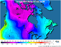
As I mentioned in my previous post, it looks like another potent cold front is going to drop out of Canada and bring some weather changes to much of Colorado including Denver on Wednesday. With still several days to tweak the forecast I will refrain from getting too excited, or specific, and instead will just mention a good chance of cold Canadian air and some snow to effect the area for Wednesday into Thursday.

Much of the nation is already under a deep freeze. The first map from the Weather Channel and shows current wind chill values in the U.S., the second is from the Weather Underground and shows the cold Canadian air mass waiting in the wings.
January tends to be a pretty calm month for Denver. The National Weather Service's climatology page states it is Denver's coldest month, and fifth snowiest. The coldest temperature ever recorded in Denver of -29 degrees F occured during the month of January. Wind is often the biggest story of the month, providing us with those warm windy days so common during the early part of last year. Last January also made it in the top five for driest Januaries on record - let us hope 2010 starts a little wetter (and colder) than 2009!

Monday, December 21, 2009

Winter to Return

We will push 60 degrees again today as a warm, dry southerly wind gets pushed into the state ahead of the next cold front due in Tuesday night. A lot of uncertainty remains surrounding the exact track of this storm. At this point it looks like it will remain well south of the area bringing us just light snow over a prolonged period. The NWS is forecasting 3-6 inches with this current path, but suggests the storm is still far enough out that this could change quite a bit in the next 24 hours. For now the only advisories for the plains are well east of Denver where it looks like even with a southerly track the storm will be a bit stronger. The other story will be the cold. By Thursday temperatures will be some 40 degrees cooler than today.

According to this article by the NWS, the chance of there being at least an inch of snow on the ground for Christmas is about 36% over the last 107 years in Denver. The chance of measurable snowfall on Christmas day is about 13%.... Looks like this year we may at least have the former of the two!

Monday, October 26, 2009

Snow! Snow! ...Snow?

The National Weather Service has issued a *winter storm watch* for most of the mountains and the urban corridor from late Tuesday night through Wednesday night. At this point the forecast is calling for 6 - 12 inches of snow during this period, with "areas of blowing snow and reduced visibilities" (nws). A winter storm watch means that there is the potential for a decent storm - but with plenty that still needs to come into place - not a certainty. The blue shaded areas on the left image show the areas under the winter storm watch, the image on the right is the current radar (weather.com) with the approaching storm in the northwest. (click to enlarge)


Keep in mind there are still many details to be worked out in the next 24 hours as this storm starts to take shape. In the latest forecast discussion by the NWS they discussed a number of concerns that may limit the amount of snow fall we actually see. Those include the uncertainty surrounding the duration of the storm (some models suggest it will move faster than others), the potential for dry slots and downsloping wind (hindering upslope favorable for Denver, and keeping heaviest snow accumulation west and east of Denver). That said, they seem to think 6 - 12 inches is a good compromise as some models are suggesting upwards of 18 inches, and other predicting less.

This blog will be following the any developments very closely over the next 12 - 24 hours! Stay tuned!

Wednesday, October 7, 2009

Beautiful today... Then SNOW!

Things are about to get real interesting around here, and in a hurry. After a picture perfect day today with highs in the low 70s, the bottom will drop tomorrow as cold airmass from Canada dips south during the day bringing Denver a good chance of snow tomorrow afternoon and evening. Although chances are "likely," the NWS thinks accumulations will be light. Just in case the forecast falls apart and it does not snow tomorrow night, we have another decent chance for snow from Friday night through Saturday. Saturday's highs will likely not break the 40 degree mark.

Denver's average first snowfall is October 19th... Looks like this year that could come early. Stay tuned as details for accumulations, temperatures, and timing will continue to get worked out!

Saturday, September 19, 2009

Big Changes Brewing

While the first day of Fall is not officially until Tuesday, Monday will feel more like Fall than Summer. Over the last several days forecasters have continued to lower the expected highs on Monday as they continue to tweak the forecast details. As it stands, it looks like we will struggle to make it out of the 50s, and lows will dip into the upper 30s for the first time in quite awhile. Clouds and rain are also looking likely for Monday - but it remains unclear how long the soggy weather will stick around as some models have the low moving through much fast than others. From Monday on there is a general warming trend, the exact track of the low will determine how quickly this occurs. At this point it does not appear that 80s will be returning any time next week.

It shouldn't get cold enough for snow here in Denver. Travel 20 miles west and that could be a completely different story. Looks like this cold front will bring the first blast of winter weather for the Mountains and even some foothill locations.

---------------------------------------> New poll!